
Find San Antonio Neighbors by Block
Public records can describe the block around an address without becoming a list of everyone who lives there. The parcel map shows property geometry and public appraisal fields. A deed can establish a recorded legal transaction. Historical maps and directories add a dated address clue, while the association layer identifies a civic boundary and contact information where published. Start with the smallest defined area, then label each finding by source and date.
| Block source | What it can show | Access route |
|---|---|---|
| BCAD parcel map | Adjacent parcel polygons, identifiers, situs, owner, mailing, and value fields | Public map with radius, measurement, and export controls |
| Bexar parcel REST layer | Queryable geometry and parcel attributes | Public ArcGIS JSON, GeoJSON, or PBF query route |
| City Archives tax maps | Historic blocks, street numbers, and tax-map context | Online search, then appointment for originals |
| Bracey’s Block Maps | 1962 north-half owners, dimensions, lots, blocks, and street numbers | SAPL Texana guide and library access |
| Sanborn 1912 | Building footprints, use, and block context in the map year | Library of Congress digital images |
| Directory or criss-cross run | Dated people or businesses at a street number | SAPL books or microfilm, with incomplete runs |
| Neighborhood layer and registry | Association boundary, public contact, meeting, website, and registry status | Bexar GIS layer and City registry |
Owners, mailing contacts, association contacts, and people shown in an old directory are different categories. A parcel entry is not an occupancy finding, and a historic directory entry does not establish a current neighbor.
Map San Antonio Block Parcels
Use the parcel polygon, not a guessed radius, to define the immediate block. The Bexar layer supports geometry queries and exposes fields including situs, owner, mailing address lines, property and account IDs, legal description, neighborhood, year built, and shape. Touching or nearby polygons can be inspected after the target parcel is found. A radius is a useful approximation, but it can cross a street edge or include a parcel that is not on the same block.
- Locate the target address in the BCAD Map Search or the Bexar parcel service, and save its situs, property identifier, legal description, and polygon.
- Inspect polygons that touch or sit immediately beside the target. Record each situs and identifier before copying any owner or mailing field.
- Overlay the neighborhood-association and ZIP layers. Mark a boundary crossing rather than forcing a parcel into one postal or association label.
- For a recorded ownership question, pivot the legal description, address, or party name to the County Clerk index and retain the instrument number and recorded date.
- Use a dated directory, tax map, or Sanborn sheet only when the question concerns the block in that source’s own year.
The process is address to target parcel to touching geometry to public parcel fields to recorded deed evidence. A broader named-street trail belongs in the San Antonio Street Directory, where the search methods are designed for a full street rather than one immediate block.
Read San Antonio Parcel Fields
The parcel layer’s Situs field is the physical site. Owner and the address-line fields are appraisal ownership or mailing attributes, while the legal description is the formal location wording used to pivot into recorded material. PropID and AcctNumb are practical identifiers for matching a map result with the appraisal and tax routes. The Shape field is the geometry that makes the nearby-parcel comparison possible.
Values, exemptions, use indicators, building area, year built, and neighborhood fields offer context, but they should not be turned into claims about a particular household. The metadata describes annual updating after final appraisal, generally in September or October, and also carries an older service marker. Keep a source date with every result rather than treating the map as a live status feed.
Note: A mailing address can differ from the mapped situs address, so label each field before comparing parcels.
Use San Antonio Radius Carefully
BCAD provides radius search, measurement tools, neighborhood and subdivision analysis, map printing, result export, and a separate results table. Its limit of 1,000 rows matters when a street-name query is broad. Use radius only to create a review area, then inspect the visible parcel edges and record the criteria used. It is not an official boundary for a block, neighborhood, or postal area.
The Bexar ZIP layer is another overlay, not a substitute for parcel geometry. Five-digit ZIP polygons are postal areas and may not follow city limits, parcels, or neighborhood boundaries. A result near the edge needs the parcel layer, the municipal address route, and the ZIP overlay compared side by side. That is the geography safeguard for a San Antonio neighbor search.
Match San Antonio Blocks to Associations
The Bexar Neighborhoods layer is a polygon dataset for San Antonio neighborhood-association boundaries. It can be queried by association name or geometry. Its fields include primary and alternate contact, phone, email, address, council district, meeting day and location, website, last update, founding date, member count, source, status, notes, and shape. Intersect the target point or parcel with the polygon, then compare the result with the City registry.
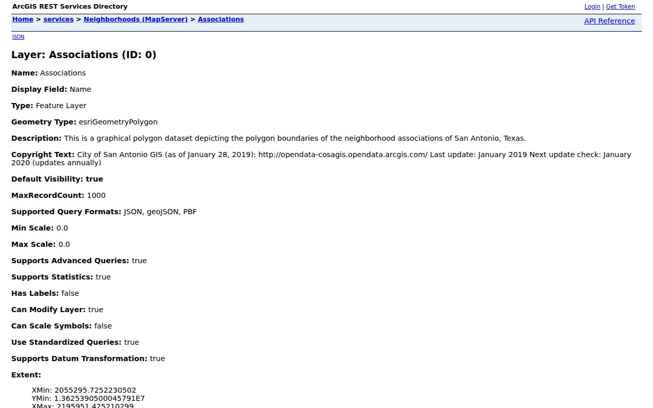
The boundary-layer image shows the type of association fields available for a block-level civic lookup. It does not establish residence at any individual parcel.
| Association route | Useful fields | Important limit |
|---|---|---|
| Bexar Neighborhoods GIS layer | Boundary, contacts, council district, meeting, website, update, source, status, notes | Layer metadata has an annual-update note; compare it with the registry |
| City Association & Organization Registry | Voluntary association listing and required boundary-map registration | Updated monthly and supplied by registrants; city disclaims completeness, accuracy, timeliness, bylaw verification, and legal-record status |
| Rights and Regulations route | Membership and city-role context for an association | The city does not regulate or enforce association bylaws |
The registry includes neighborhood and homeowner associations. Neighborhood-association boundaries may not overlap one another, while homeowner-association boundaries may overlap neighborhood-association boundaries. Registry listing is a civic-network lead, not proof of a neighbor at an address.
Compare San Antonio Neighbor Sources
When a block question needs a reliable answer, begin with the custodian that holds the underlying record. Commercial neighbor-lookup tools are a category, not a record custodian. The research documents no provider-specific collection or completeness standard for that category, so a result from it should be checked against the official parcel, deed, archive, or registry route before it is relied upon.
| Source category | Best use | What to verify |
|---|---|---|
| Official parcel and deed sources | Mapped parcel fields and recorded legal instruments | Record date, legal description, instrument number, and whether a field is ownership or mailing data |
| Official association sources | Boundary and voluntary civic-contact context | Registry status, update date, and the city’s stated disclaimer |
| Historic maps and directories | Block context for a known edition or map year | Repository, edition, page, and the difference between a historical address clue and current status |
| Commercial neighbor tools | A possible lead only | Underlying source, date, identity match, and the official custodian record |
Read San Antonio Block History
City Archives offers a digital search route for deeds, city tax maps and red books, plats and maps, minutes, ordinances, resolutions, and election results. The research warns that physical collections are not fully online. For a missing block page, use the online finding aid first, then request an appointment with the Archives and bring the street, block, map, date range, and known identifiers. The records-request route is for defined existing city maps or administrative material, not a new compilation.
The City Archives NCB plat-map finding aid identifies 154 books of about 100 pages and page-by-page street and block aids. Bracey’s Block Maps provide a different 1962 north-half snapshot, while the 1912 Sanborn volume supplies building footprint and use context. These sources can show what stood beside a parcel at a stated time, but they must not be read as present-day neighbor evidence.
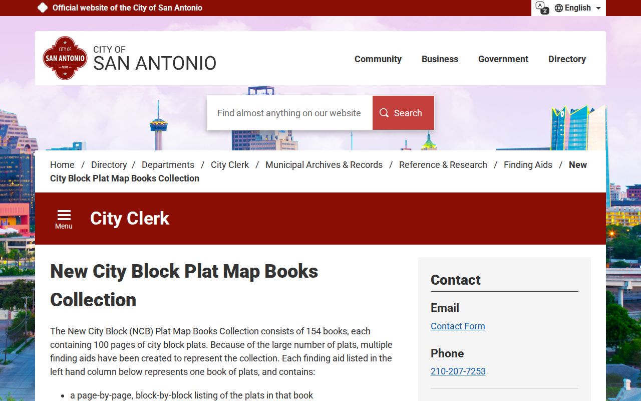
The finding-aid image supports an address-to-map fallback when a current parcel map has no historical block detail or the required page is not online.
Limit San Antonio Voter Results
The Bexar voter lookup requires date of birth, house number, and last name, then returns a registered address, precinct, and election information or a no-information response. It has no street-only query or export. For a block question, parcel geometry is the geographic index. Individual voter lookup is not a substitute for a block roster.
Protected addresses may be suppressed or replaced under Texas confidentiality routes. The research also distinguishes individual lookup from the state voter-file request process, which has a notarized affidavit, deposit, media choices, filters, and statutory-use acknowledgment. Preserve a protected display state rather than attempting to infer the address from another record.
Protect San Antonio Neighbor Privacy
San Antonio neighbors cannot be identified with certainty from a single public source. A parcel owner may use another mailing address, association contacts speak for a group rather than every resident, and a directory entry belongs to a past edition. Restricted County Clerk records are excluded from ordinary public access. A missing entry can mean a source limit, not an absence of a person or event.
BCAD offers a web-suppression application for a property record, while the Texas SOS and Attorney General have address-confidentiality paths with their own eligibility and access rules. Web suppression is not deletion from every legal or archival record. Use the smallest public field set needed, and do not reproduce protected addresses, identification numbers, full dates of birth, or private image details.
Lawful use. Use San Antonio neighbor records for family history, civic context, property questions, or careful personal research. Do not use them to stalk, harass, or harm anyone, and leave protected information protected.